Hurricane Lee Massachusetts: Tropical Storm Warning Issued for New England Coastline
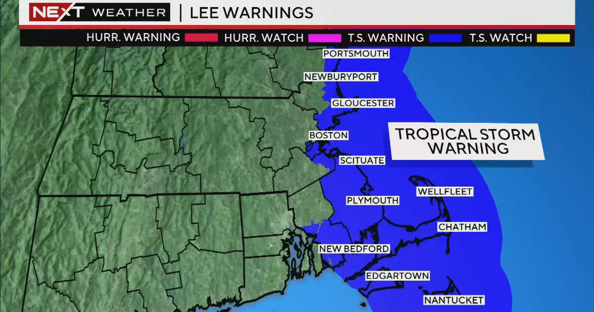
Tropical Storm Warning issued for New England coast. Hurricane Lee to make closest approach on Saturday morning. Cape Cod and Nantucket to experience strongest winds and heaviest rainfall.
A Tropical Storm Warning has been issued for the entire coastline of Rhode Island, Massachusetts, New Hampshire, and Maine. Additionally, there is still a hurricane watch for the far northeastern coastline of Maine.
The hurricane, named Lee, is currently a Category 1 hurricane but is expected to gradually weaken. It is moving due north and increasing its forward speed.
Lee will come closest to New England on Saturday morning, likely as a minimal Category 1 hurricane, before transitioning into an extra-tropical storm similar to a nor'easter.
The projected landfall for Lee is in the Bay of Fundy area late Saturday night.
Today, the forecast confidence has significantly increased regarding Lee's final track and impacts. The current forecast predicts that the center of the storm will pass about 150 miles east of the Outer Cape on Saturday morning.
As a result, the majority of the impacts will be felt over Cape Cod and Nantucket, particularly on the Outer Cape.
For those living inland, away from the coastline, there will be minimal rain and only some gusty winds.
The first rain bands are expected to reach the Islands and Cape Cod around sunset on Friday.
The heaviest rain and strongest winds will occur when the center of the storm makes its closest pass, which will be late Friday night through midday on Saturday.
As Lee accelerates and moves towards the Bay of Fundy and Canada, the rain and wind will quickly taper off during the afternoon hours, reaching parts of northern New England, specifically Maine.
The areas closest to the center of the storm, such as far eastern MA and Cape Cod, will experience the heaviest rainfall. Inland areas may see very little, if any, rainfall on Saturday.
Similarly, the strongest winds will be in easternmost southern New England, primarily over the Outer Cape. Gusts between 50-65mph are expected there during Saturday morning.
Along the rest of the coastline, peak gusts will range between 40-50mph.
Further inland, west of I-95, gusts should reach a maximum of 25-40mph.
The greatest impact from Lee will be felt in the coastal waters and along the shoreline. Waves of 10-20 feet and some coastal erosion are anticipated. A minor storm surge of 1-3 feet is also expected on Saturday. Fortunately, the tides are currently astronomically low, and the peak of Lee's impact and wind is expected to coincide with low tide on Saturday morning.
We will continue to provide frequent updates before and during the storm on WBZ-TV, WBZ.com, and CBS News Boston. Rest assured, we have you covered!


Comments on Hurricane Lee Massachusetts: Tropical Storm Warning Issued for New England Coastline