Vermont Bracing for Potential Severe Flooding Similar to Irene
Flash flooding continues in Northeast, particularly in Vermont; impacts not seen since 2009.
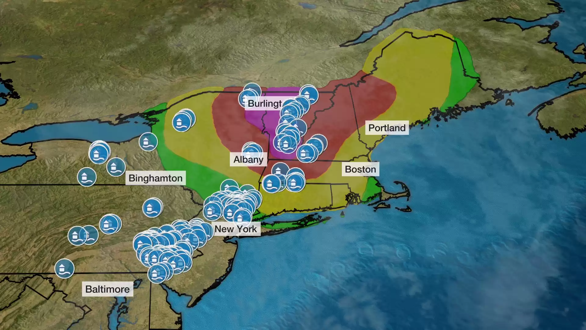
Flash flooding poses a dangerous and life-threatening situation in parts of the Northeast, particularly in Vermont, where the impacts could be the most severe in almost 12 years. The National Weather Service office in Burlington, Vermont, has issued a warning of significant to potentially catastrophic flash flooding, with possible impacts similar to those seen during Hurricane Irene.
The East has already experienced over 200 reports of flash flooding since Sunday morning, stretching from upstate New York and Vermont near the Canadian border to North Carolina. One of the hardest-hit areas on Sunday was the vicinity of the U.S. Military Academy at West Point, New York, where nearly 7 inches of rain fell in just three hours, leading to vehicles being trapped and roads being washed out. The rainfall rates in this area were estimated to have a 0.001 percent chance of occurring in any given year.
In Stormville, located about 15 miles northeast of West Point, the highest rainfall total reached 8.61 inches in a 24-hour period ending Monday morning. Northwest Connecticut also experienced flooding, resulting in washed-out roads and flooded homes in the town of Norfolk. Eastern Pennsylvania saw 3 to 6 inches of rain, leading to flooded roads and water rescues. Reading, Pennsylvania, even had its wettest July day on record, surpassing records dating back to the Civil War.
Currently, the heaviest rain is falling from Connecticut to Massachusetts, upstate New York, Vermont, and New Hampshire. Flood watches remain in effect for these areas, with a flash flood emergency declared for parts of central Vermont. The town of Ludlow reported over 5 inches of rain, causing numerous road closures and flooding. At one point, flash flood warnings covered almost the entire state of Vermont.
Before the system clears out by early Tuesday, this region is expected to receive another 2 inches of rain or more. Combined with the previous rainfall on Friday, this additional precipitation could lead to widespread flash flooding, especially in mountainous areas. Some roads may be washed out, and flooding of larger rivers in western and northern New England is also possible.
Unfortunately, more rain is expected to move into the Northeast later this week, with potential rounds of flash flooding on Thursday, Friday, and possibly next weekend. While the details are still uncertain, it is crucial to stay updated with the latest forecasts from weather.com.
Looking back at Hurricane Irene in August 2011, the storm made landfall in eastern North Carolina and then tracked through New Jersey to Vermont as a tropical storm. Irene caused significant inland flooding in northern New England and upstate New York, particularly in Vermont. The floods resulted in the destruction or damage of nearly 2,400 roads, 800 homes, and numerous bridges, making it Vermont's worst natural disaster since a flood in November 1927. In New York, three Catskill Mountain towns were left uninhabitable. During Irene, 26 monitoring stations, including 11 in Vermont, broke all-time daily precipitation records, according to NOAA's National Centers For Environmental Information.


Comments on Vermont Bracing for Potential Severe Flooding Similar to Irene