Researchers use deep learning to enhance spatial temporal resolution coarse precipitation maps
New AI method developed by researchers at KIT improves precision of global climate models, helping to forecast and prepare for natural disasters.
The impact of strong precipitation on natural disasters such as flooding and landslides is well-documented. Global climate models are crucial for predicting the frequency of extreme weather events, particularly in the context of climate change. Researchers at the Karlsruhe Institute of Technology (KIT) have developed an innovative method based on artificial intelligence (AI) to enhance the precision of coarse precipitation fields generated by these models.
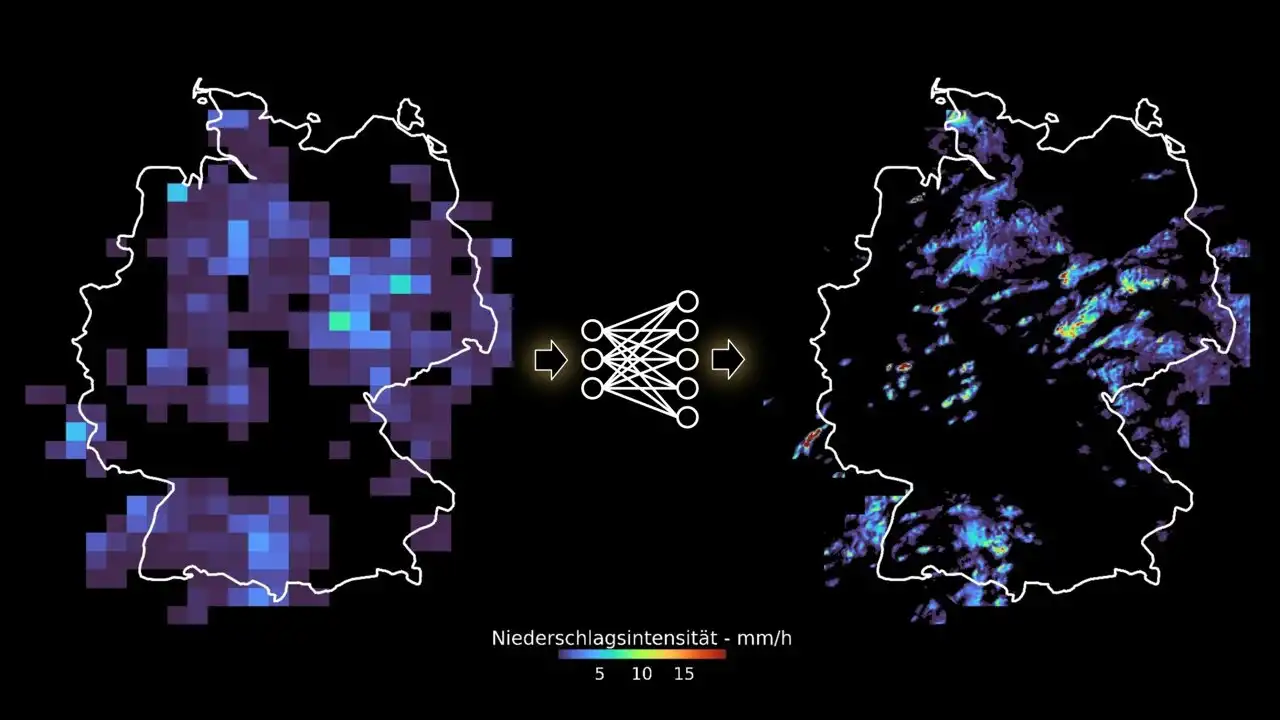
The team achieved a significant improvement in the spatial and temporal resolution of precipitation fields, from 32 to two kilometers and one hour to 10 minutes, respectively. This enhanced resolution is essential for accurately forecasting the increasing occurrence of heavy local precipitation and the subsequent natural disasters that are expected in the future. Their groundbreaking study has been published in the prestigious journal Earth and Space Science.
Extreme precipitation is a direct driver of many natural disasters, and with rising global temperatures, it is anticipated that these events will become more frequent and severe. As such, precise local and global data on the current and future water cycle are critical for adapting to a changing climate and mitigating the impact of disasters.
Dr. Christian Chwala from KIT's Institute of Meteorology and Climate Research (IMK-IFU) emphasizes the challenges of forecasting precipitation due to its high variability in space and time, particularly at the local level. The researchers' goal is to improve the resolution of precipitation fields generated by global climate models and enhance their ability to identify potential threats such as flooding.
Existing global climate models are limited by their grid resolution, which hinders their ability to accurately represent precipitation variability. The researchers addressed this issue by developing an AI-based generative neural network, known as GAN, and training it with high-resolution radar precipitation fields. This innovative approach allows the network to generate highly resolved radar precipitation maps from coarsely resolved data, offering a more accurate representation of precipitation patterns and statistics.
The team's deep learning method significantly outperforms traditional numerical weather models in terms of speed and computational efficiency. Moreover, it produces an ensemble of different potential precipitation fields, providing a more comprehensive understanding of the associated uncertainty, similar to a weather forecast.
The results of this study have far-reaching implications for the future of climate modeling. The AI model and methodology developed by the researchers will enable improved spatial and temporal resolution of precipitation in climate simulations, allowing for a more precise analysis of the impacts and developments of precipitation in a changing climate.
Looking ahead, the researchers plan to apply their method to global climate simulations, projecting specific large-scale weather situations into a future world with a changed climate. This will provide invaluable insights into the potential impacts of climate change on extreme weather events, informing crucial climate adaptation strategies.


Comments on Researchers use deep learning to enhance spatial temporal resolution coarse precipitation maps